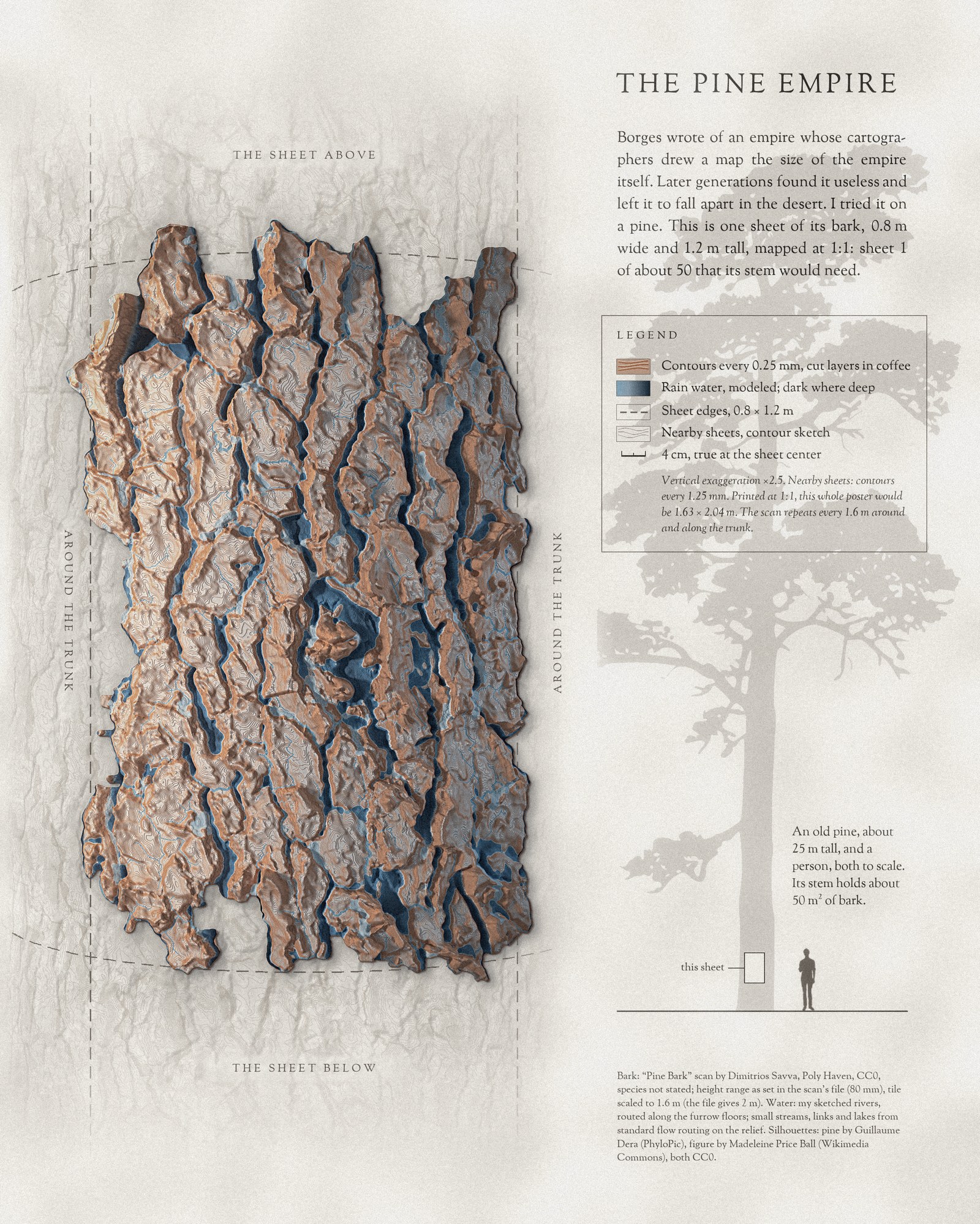
Day 14 is the Borgesian map. In Borges’s one-paragraph story, the cartographers of an empire draw a map as large as the empire itself; later generations find it useless and leave it to fall apart in the western deserts.
I tried it on something small enough to finish: the bark of a pine. This sheet is mapped at 1:1. Printed at full size, the poster would be 1.63 m wide, and the sheet on it would cover exactly the 0.8 × 1.2 m of bark it shows. At that scale bark stops being a texture and starts reading like terrain. The thick plates rise as ridges and plateaus, the furrows between them become canyons, and modeled rain, treating the bark as ground, gathers in furrow rivers and small lakes.
Around the sheet, the nearby sheets are only sketched in contours. The trunk is round and goes on above and below: an old pine about 25 m tall has roughly 50 m² of bark on its stem, so it would take about fifty sheets like this one, before a single branch.
Method
The relief is the height map of Poly Haven’s “Pine Bark” scan, with the height range given for it (80 mm); the species isn’t stated. Poly Haven gives the tile as 2 m across; I scaled it to 1.6 m, so the plates are about 9 cm wide. Heights are drawn at 2.5 times their true value and cut into paper layers every 0.25 mm. I sketched the main rivers by hand along the furrow floors; the small streams, the links between lakes and the lakes in closed hollows come from standard flow routing on the same relief, with the bark treated as ground lying flat. It is a model, not a measurement of stemflow on a standing tree. The stem area assumes a paraboloid stem about 1 m across at the base. Rendered in Blender, composed in Python.
References
- Borges, J. L. (1946). Del rigor en la ciencia (“On Exactitude in Science”). Los Anales de Buenos Aires 1(3).
- “Pine Bark” by Dimitrios Savva, Poly Haven (CC0).
- Silhouettes: pine by Guillaume Dera (PhyloPic, CC0); figure by Madeleine Price Ball (Wikimedia Commons, CC0).