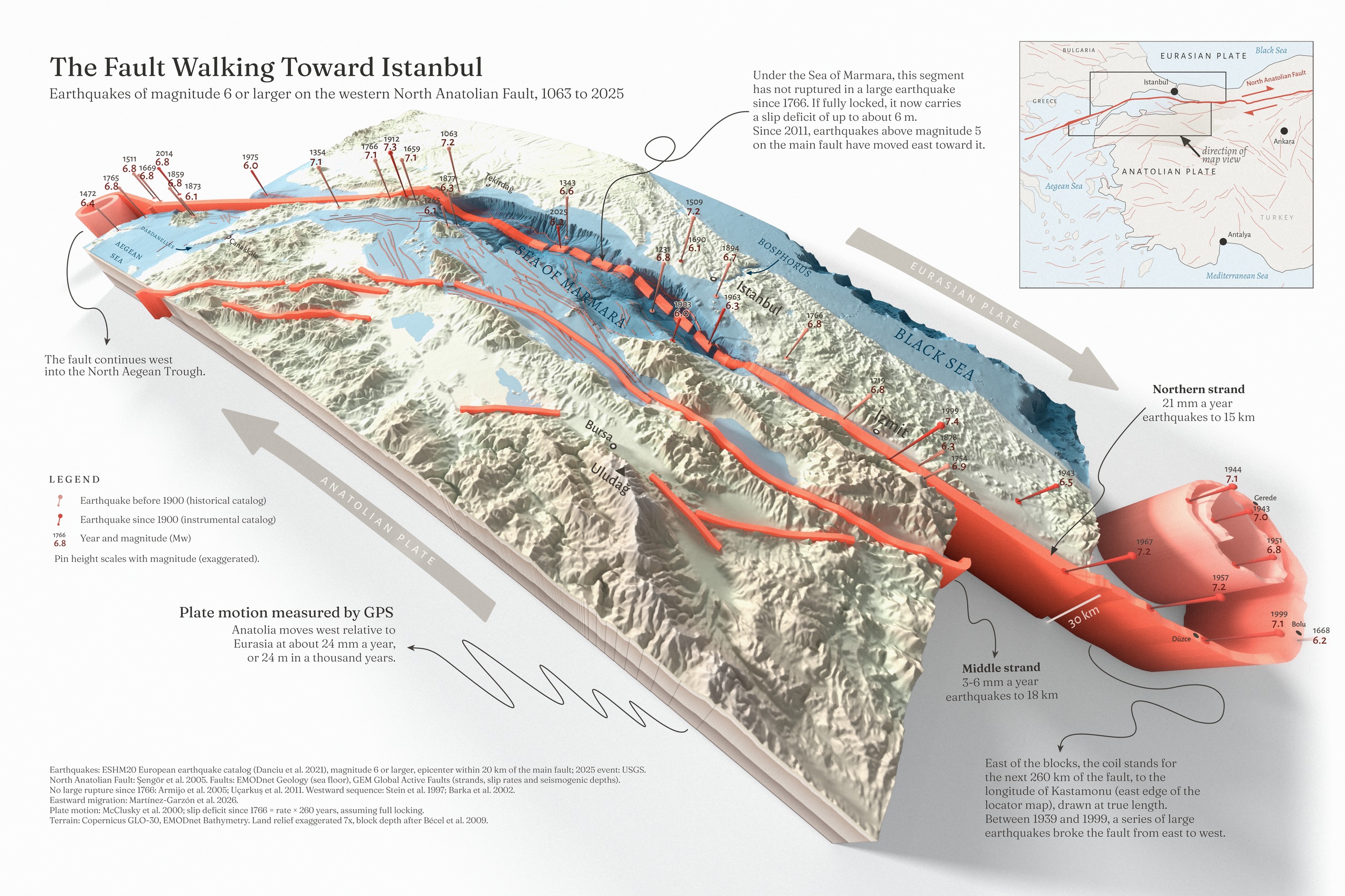
If you grow up in Türkiye, you grow up hearing about this fault. The North Anatolian Fault runs about 1,200 km across the north of the country, and along it Anatolia slides west past Eurasia, about 24 mm a year. But it doesn’t slide smoothly. It sticks, sometimes for centuries, and then one segment lets go in a large earthquake. Between 1939 and 1999 that happened again and again, one segment after the next, walking from Erzincan in the east all the way to İzmit and Düzce. Then the fault reaches the Sea of Marmara. There, 15 to 25 km off Istanbul’s shore, a stretch of about 100 km hasn’t broken in a large earthquake since 1766. That’s the part I wanted to look at closely.
The unbroken stretch
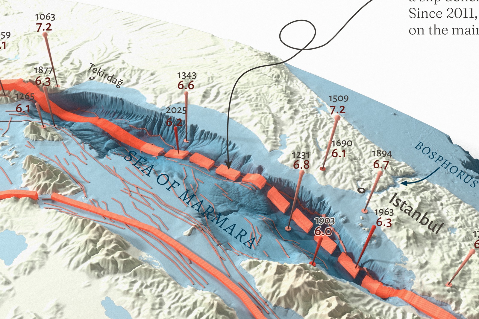
On the map it is the dashed part of the red ribbon, from the Central Basin (28.0° E, where the 1912 Mürefte-Şarköy rupture ended) to the entrance of the Çınarcık Basin (29.24° E, where the 1999 İzmit rupture ended). Published estimates of its length run from about 100 to 150 km, depending on where the 1912 rupture is taken to end; the ends used here give about 106 km. If the stretch is fully locked, 260 years at 24 mm a year add up to a slip deficit of about 6 m. That is an upper bound, because parts of the western stretch creep slowly instead of locking.
The stretch has not been silent. Since 2011, earthquakes above magnitude 5 on the main Marmara fault have stepped east along it: two in 2011 and 2012, the 2019 Silivri earthquake (Mw 5.8) and the 23 April 2025 earthquake (Mw 6.2), the largest on this fault in more than 60 years. Martínez-Garzón and colleagues read this as a gradual eastward partial rupture toward the locked segments south of Istanbul. The 2025 earthquake released only about 20 cm of the estimated deficit.
Making it
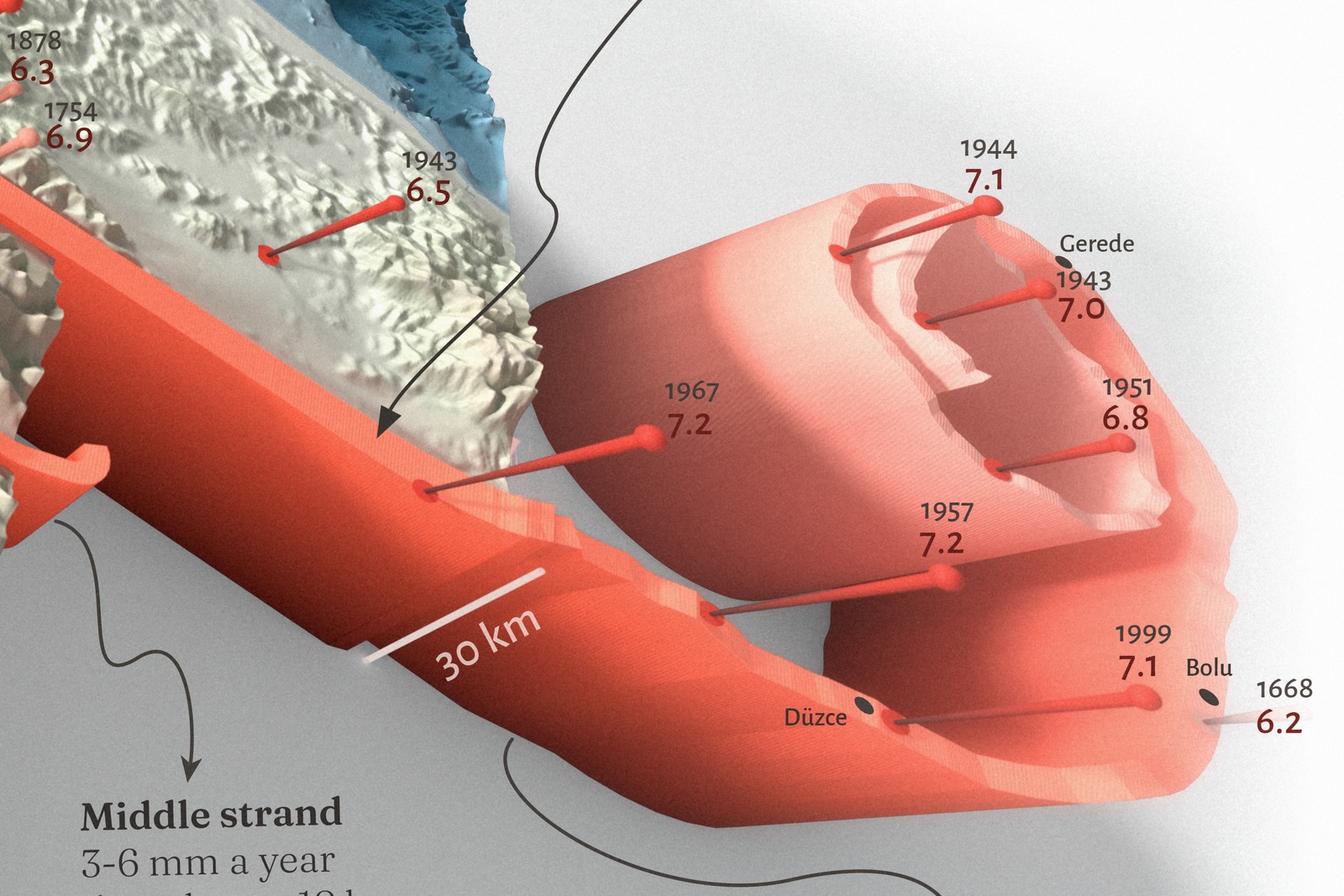
The theme was Lines, and the first line I wanted to draw was a fault. I started this one in mid-October as two blocks of crust sliding past each other along a single red line, and it slowly grew into a small obsession. The terrain is Copernicus GLO-30 on land and EMODnet bathymetry under the sea. I smoothed the land a little in Python so the relief stays calm, and left the sea floor raw so every basin and scarp shows. The block was built in Blender with Geometry Nodes and rendered in Cycles, and the red ribbon, the pins and the coil are all generated from the data, so every pin stands on its epicenter. My favorite part is the coil: the fault didn’t fit on the block, so instead of cutting it off I rolled the next 260 km up at true length, like a measuring tape. The last change was the dashed stretch, placed from the published ends of the 1912 and 1999 ruptures. Then the labels, the layout and the final color and grain, all by hand in Illustrator and Photoshop. It took longer than I planned, mostly because a new idea kept turning up every time I sat down with it. I even wanted to draw a little comic to go with it; that one is still on my list.
Data and method
Pins mark every earthquake of magnitude 6 or larger with its epicenter within 20 km of the main fault, from the ESHM20 European catalog (1063 to 2014), plus the 2025 Mw 6.2 from USGS. Pale pins come from the historical catalog (before 1900), dark red ones from instrumental records; each is labeled with year and moment magnitude (Mw), and pin height scales with magnitude, exaggerated. Historical epicenters are uncertain by tens of kilometers. The red ribbon is the main strand of the fault, dashed where it has not ruptured in a large earthquake since 1766. East of the block it rolls up into a coil holding the next 260 km of the fault, to the longitude of Kastamonu, at true length; to the west the fault continues into the North Aegean Trough. The two thinner red ribbons are the middle and southern strands of the fault, which split off the main (northern) strand east of the block (GEM Global Active Faults). The northern strand carries most of the motion, about 21 mm a year; the middle strand 3 to 6 and the southern strand 3 to 4 mm a year. Earthquakes on the northern strand occur down to about 15 km, on the other two to about 18 km. Thin pale red lines are faults on the sea floor (EMODnet Geology); two old Black Sea structures were left out because they are not mapped active faults. Wide gray arrows show the motion of the two plates. Land relief is exaggerated seven times; the block is 30 km deep at true scale, about the depth of the Moho under the Sea of Marmara. The slip deficit assumes the full plate rate and full locking since 1766. Rendered in Blender (Cycles); layout in Illustrator and Photoshop.
This map shows past earthquakes and published research. It is not a forecast or a warning; for official information, follow AFAD and the Kandilli Observatory.
References
- Danciu, L. et al. (2021). The 2020 update of the European Seismic Hazard Model (ESHM20): unified earthquake catalogue. EFEHR, doi:10.12686/a15 (CC BY 4.0).
- USGS ComCat, event us7000pufs: M 6.2 Marmara earthquake, 23 April 2025.
- Styron, R. and Pagani, M. (2020). The GEM Global Active Faults Database. Earthquake Spectra 36, 160-180 (CC BY-SA 4.0). Strands, slip rates and seismogenic depths.
- EMODnet Geology: sea-floor faults, 1:100,000 (CC BY 4.0).
- Şengör, A.M.C. et al. (2005). The North Anatolian Fault: a new look. Annu. Rev. Earth Planet. Sci. 33, 37-112.
- Kürçer, A. et al. (2008). Tectonophysics 453, 263-275 (the Yenice-Gönen fault).
- Armijo, R. et al. (2005). Submarine fault scarps in the Sea of Marmara pull-apart (North Anatolian Fault): implications for seismic hazard in Istanbul. G-cubed 6, Q06009.
- Uçarkuş, G., Çakır, Z. and Armijo, R. (2011). Western termination of the Mw 7.4, 1999 İzmit earthquake rupture: implications for the expected large earthquake in the Sea of Marmara. Turkish J. Earth Sci. 20, 379-394.
- Bohnhoff, M. et al. (2013). An earthquake gap south of Istanbul. Nat. Commun. 4, 1999.
- Stein, R.S., Barka, A.A. and Dieterich, J.H. (1997). Progressive failure on the North Anatolian fault since 1939 by earthquake stress triggering. Geophys. J. Int. 128, 594-604.
- Barka, A. et al. (2002). The surface rupture and slip distribution of the 17 August 1999 İzmit earthquake (M 7.4), North Anatolian Fault. BSSA 92, 43-60.
- Martínez-Garzón, P. et al. (2026). Progressive eastward rupture of the Main Marmara fault toward Istanbul. Science 391, 379-383, doi:10.1126/science.adz0072.
- McClusky, S. et al. (2000). Global Positioning System constraints on plate kinematics and dynamics in the eastern Mediterranean and Caucasus. JGR 105, 5695-5719.
- Bécel, A. et al. (2009). Moho, crustal architecture and deep deformation under the North Marmara Trough. Tectonophysics 467, 1-21.
- Copernicus DEM GLO-30 © DLR e.V. 2010-2014 and © Airbus Defence and Space GmbH 2014-2018, provided under COPERNICUS by the European Union and ESA; EMODnet Bathymetry (CC BY 4.0).