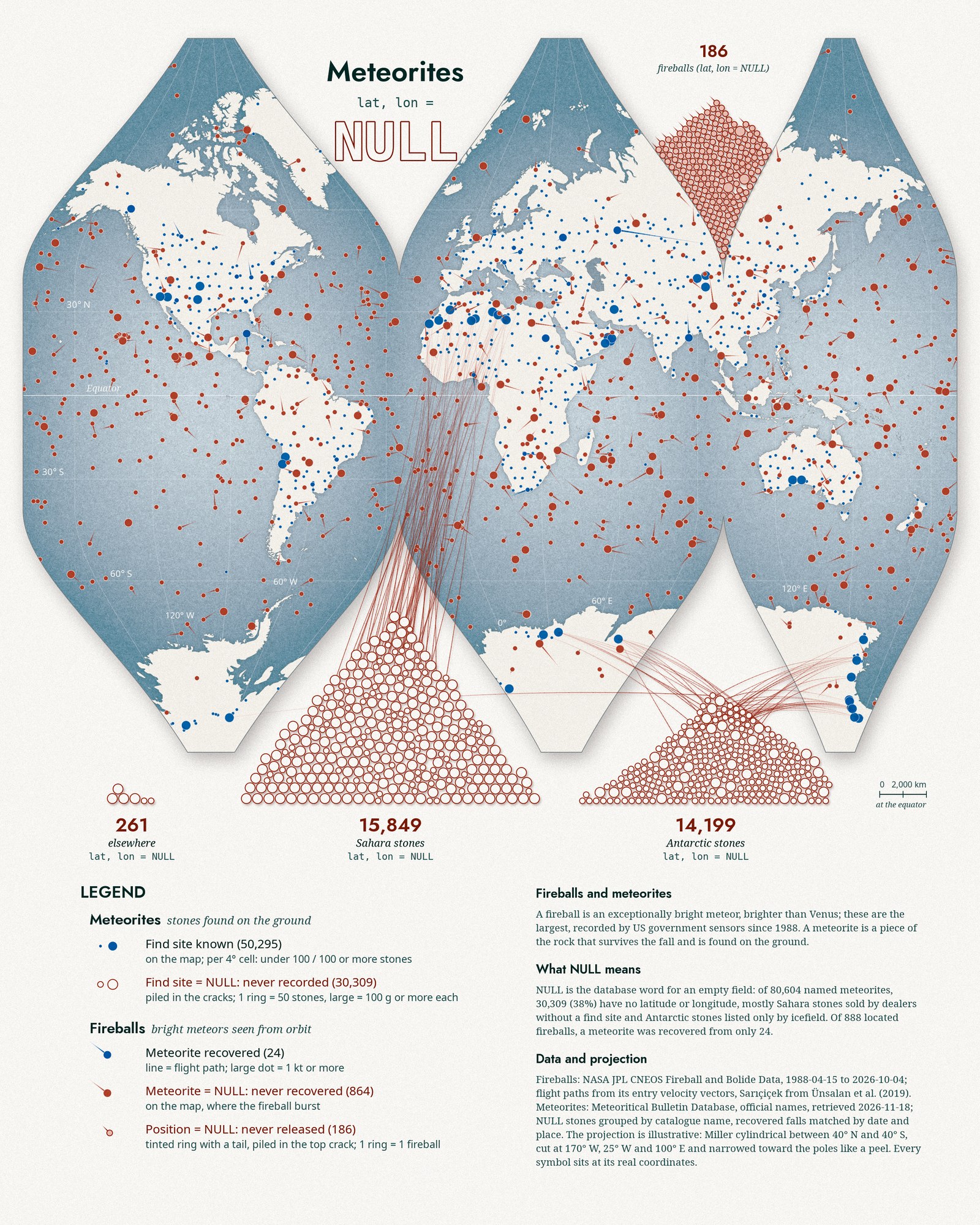
Day 18 is NULL. In a database, NULL is not zero; it is an empty field. The record exists, but the value was never filled in. Meteorites turned out to be full of them.
The Meteoritical Bulletin lists 80,604 officially named meteorites (I left out the fifteen found on Mars by rovers). 30,309 of them, 38 percent, have no latitude or longitude. Most are stones from the Sahara and Northwest Africa, sold by dealers without a find site, and Antarctic stones listed only by the icefield they came from. They are real rocks in real collections, but they have no place on a map. So I let them fall: each red ring in the piles is 50 of those stones, the large rings are groups whose stones weigh 100 g or more on average, and the thin lines start at real find sites in the same regions.
Fireballs carry a second kind of NULL. US government sensors have recorded 1,074 of the largest fireballs since 1988. 186 of them come with a time and an energy but no position. Of the 888 with a position, a meteorite was recovered from only 24; for the other 864 the meteorite field stays empty. Most of them burst over the ocean, where no meteorite could be recovered.
Method
Fireball positions and flight directions come from the CNEOS list; the direction uses its Earth-fixed entry velocity vector, turned into a local heading at the burst point. For the Sarıçiçek fall in Bingöl (2 September 2015) I used the trajectory reconstructed from videos by Ünsalan and colleagues (2019), because the satellite vector for that event is off by about 74 degrees. Meteorites with coordinates are grouped in 4-degree cells, each drawn at a real find site inside the cell. I fixed or removed a few bad source rows: one with latitude and longitude swapped, and 220 Antarctic records whose coordinates were a placeholder (0°, 35.67° E), which I counted as NULL. Recovered falls were matched to fireballs by date and distance and checked against published fall times.
The projection is illustrative, not a standard one: Miller cylindrical between 40° N and 40° S, cut at 170° W, 25° W and 100° E and narrowed toward the poles like a peeled tangerine, so polar shapes are squeezed. Every located symbol sits at real coordinates.
References
- NASA JPL Center for Near Earth Object Studies. Fireball and Bolide Data, accessed 18 November 2026.
- The Meteoritical Society. Meteoritical Bulletin Database, retrieved 18 November 2026.
- Ünsalan, O. et al. (2019). The Sariçiçek howardite fall in Turkey: Source crater of HED meteorites on Vesta and impact risk of Vestoids. Meteoritics & Planetary Science 54: 953-1008.