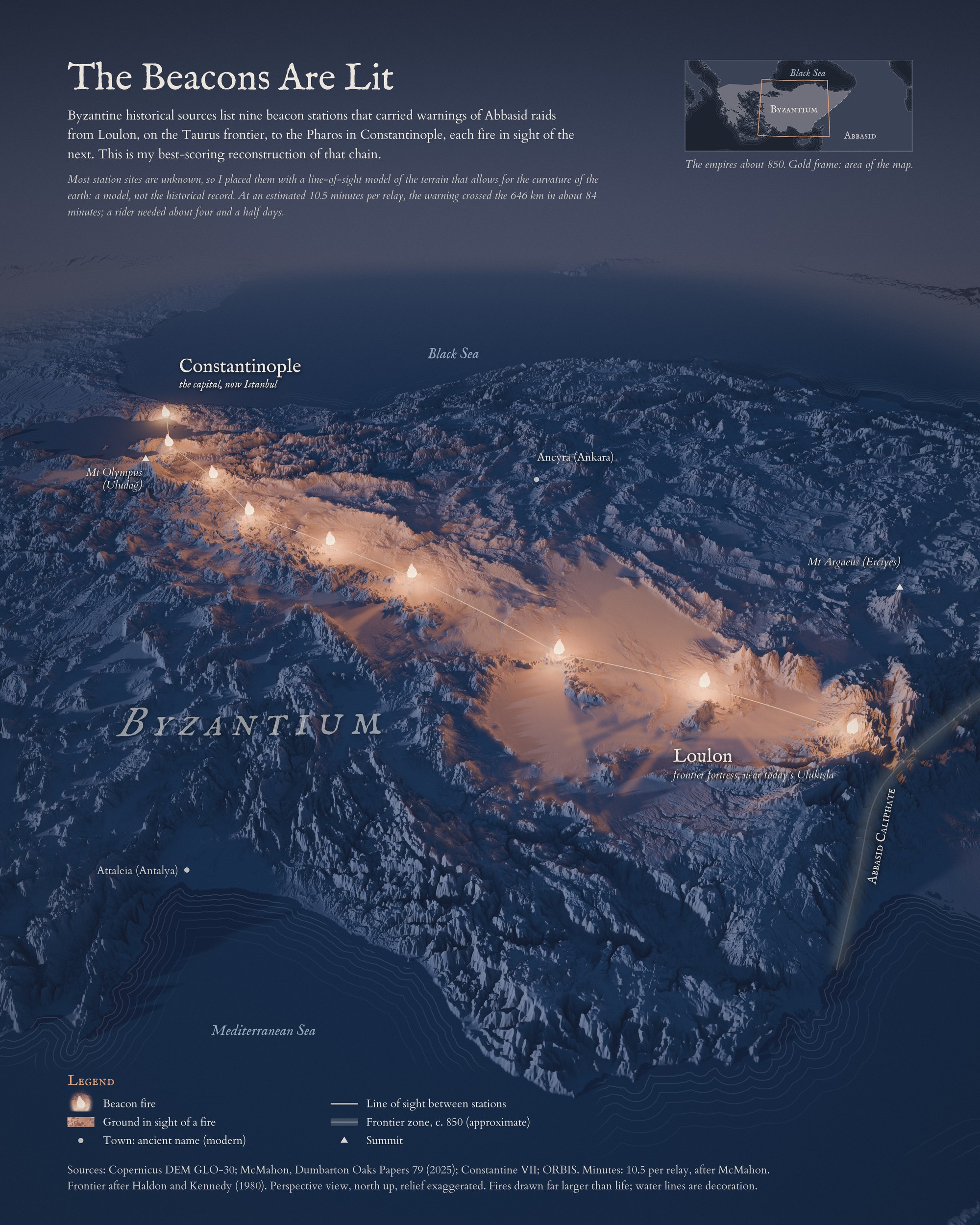
In the ninth century the Byzantine Empire faced the Abbasid Caliphate across the Taurus Mountains. Raiders came through the passes often, and a warning had to reach the emperor fast. Byzantine sources describe a chain of beacon fires from the fortress of Loulon, above the Cilician Gates, to the Pharos of the Great Palace in Constantinople, and they list its nine stations. For most of them the exact site is unknown, so the sites on my maps are my own reconstruction.
Which hills could see each other
I tested which hilltops could see a fire burning 10 m above another summit. Of 512,873 local summits in a 30 m elevation model, I kept 372 as candidates: those with a prominence of at least 300 m and a wide view. For every pair I traced a line of sight across the terrain, allowing for the curve of the earth and normal atmospheric refraction. A route search then ranked chains from Loulon to the Pharos, favoring short hops and lines that clear the ground with room to spare.
Nine fires, 84 minutes
The best chain has nine stations and covers 646 km; its longest hop is 118 km. The 84 minutes is an estimate, not a recorded time: 8 relays at about 10.5 minutes each, after McMahon (2025). A rider needed about four and a half days. Each lit area on the map is the ground from which a fire could be seen.
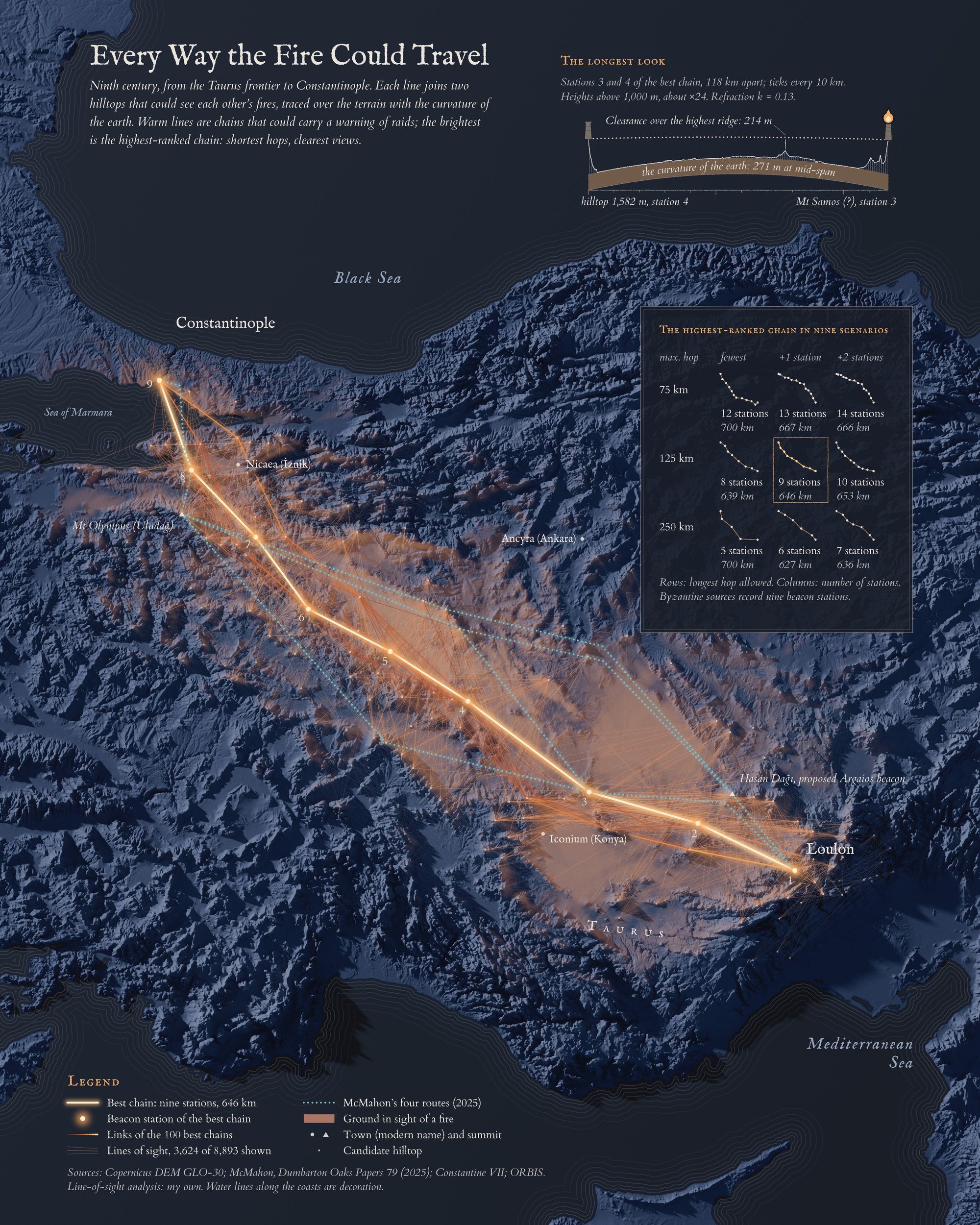
The second map shows the whole network. The warmer the line, the more of the 100 best chains use it; the brightest is the best chain. The small chains on the right repeat the search under other limits on hop length and number of stations, and the dotted lines are the four routes McMahon proposed. On the longest hop the light clears the highest ridge by 214 m, while the curve of the earth lifts the ground 271 m between the two fires.
What’s next
The result is a model, not a record. It does not test whether the eye could pick out a fire more than 100 km away at night, and it leaves out haze, weather and the true positions of the stations. It also looks for one best route. Hasan Dağı, a volcano over 3,200 m and one of the sites proposed for the Argaios beacon, sees about 18,000 km² and is in sight of Loulon, yet my best chain passes it by; a chain through it scores about 6% worse. A real system had to watch several passes at once, which may be why such a peak was used. Modeling the whole frontier instead of one route is my follow-up project.
Data and method
Copernicus DEM GLO-30. Candidate summits with a prominence of at least 300 m and a wide view; nearby summits merged. Fires 10 m above the ground; curve of the earth and refraction (k = 0.13) included. Relay time 10.5 minutes per station, after McMahon. The frontier around 850 is approximate. Perspective view, north up, relief exaggerated. The station sites are modeled, not known.
References
- McMahon, L. (2025). The Byzantine beacon system. Dumbarton Oaks Papers 79, 219-245 (beacon system, station candidates, relay time).
- Haldon, J. and Kennedy, H. (1980). The Arab-Byzantine frontier in the eighth and ninth centuries. Zbornik Radova Vizantološkog Instituta 19, 79-116 (frontier around 850).
- ORBIS: The Stanford Geospatial Network Model of the Roman World (courier time, as cited by McMahon).
- Copernicus DEM GLO-30: © DLR e.V. 2010-2014 and © Airbus Defence and Space GmbH 2014-2018, provided under COPERNICUS by the European Union and ESA.
- Natural Earth (locator coastlines).